Typhoon Kajiki approaches Vietnam’s central coast
Typhoon Kajiki, the fifth storm this season in the East Sea, is moving toward Vietnam’s central coast, Kazinform News Agency reports.
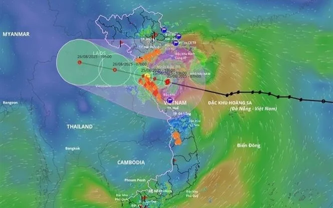
According to the National Center for Hydro-Meteorological Forecasting, on the morning of August 25, storms are expected in the north, while the south may experience scattered showers, thunderstorms, and possible tornadoes. Visibility during storms will decrease to 2–4 km. In the north, strong winds of levels 7–9 are forecast, later strengthening to 10–12, with levels 13–14 near the storm’s center and gusts reaching level 17. The sea will be rough.
Severe marine conditions are anticipated, with strong waves and storm surges. Water levels in areas such as Hon Dau and Sam Son may rise by more than 3.5 meters. Wave heights are expected to reach 4–6 meters in the northern part of the Gulf of Tonkin and 8–10 meters in the southern part.
🌪️ #TyphoonKajiki
— Gujarat Herald News (@GujaratHerald) August 25, 2025
Horrifying footage from Sanya beach resort in Hainan, China — the most powerful typhoon recorded in the region's history.
➡️ Vietnam begins mass evacuation
➡️ Airports and schools closed
➡️ Typhoon to hit coast Monday afternoon#China #Vietnam #Typhoon pic.twitter.com/JdUFaupivT
Prime Minister Pham Minh Chinh chaired a meeting in Nghe An province, instructing ministries and local authorities to prepare for the storm, develop evacuation plans, and mobilize resources to protect residents and infrastructure.
Meteorologists noted that Kajiki’s intensity is comparable to that of Typhoon Yagi, which struck the country last year. Authorities warn of potentially severe impacts in mountainous, low-lying, and coastal areas.
Earlier, it was reported that Kazhydromet issued a storm alert for 16 regions of Kazakhstan on August 25.